 |
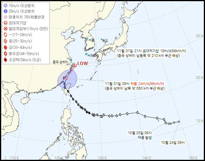
| Typhoon Kong-rey's predicted path (Korea Meteorological Administration) |
For the first time since 2017, South Korea did not experience a typhoon landfall this summer, a stark contrast to the powerful storms that hit the country in the past two years, the Korea Meteorological Administration said Friday.
Typhoon Khanun in 2023 caused floods and forced some 14,000 people to evacuate and Typhoon Hinnamnor in 2022 caused 14 casualties and six injured, as well as 244 billion won ($177 million) in property damages.
In contrast, Typhoon Krathon approached South Korea from the Philippines with strength similar to Typhoon Kong-rey on Oct. 3, but it lost momentum near Taiwan’s coast before weakening into a tropical depression.
When asked why typhoons did not strike Korea this year, the KMA told The Korea Herald that it was due to the North Pacific high pressure system that caused extreme heat in August.
“The convection activity was higher than usual this year near the northwest Pacific of the Philippines, resulting the hot, humid North Pacific high pressure system in the low to mid-levels of the atmosphere to develop bigger and longer than usual above Korea,” said KMA official Woo Jin-kyu. “The typhoons were unable to go through this high pressure system, which resulted in them moving toward China instead.”
According to the KMA, Typhoon Kong-rey made landfall in Taiwan on Thursday. The typhoon, recorded as the most powerful typhoon to hit Taiwan in 28 years, killed at least two people and injured more than 500 individuals as of Friday.
While eyes were set on whether this powerful typhoon would also hit Korea, the KMA said Thursday during a press briefing that Typhoon Kong-rey would weaken before approaching the Korean peninsula without posing a big impact on the country.
The KMA said the typhoon would quickly weaken to an extratropical cyclone between Friday and Saturday before passing the southern coast of Jeju Island. However, due to moisture and rain clouds associated with the extratropical cyclone, heavy rain will be focused on the southern parts of the country starting Friday evening until Saturday.
As the moist air from the typhoon is expected to collide with the cool air blowing into Korea from the northwest, rainclouds will be formed over the southern area resulting in rainfall of up to 30 millimeters per hour.
Jeju Island is expected to between 50 mm and 150 mm of rainfall through Saturday, with heavily hit regions expecting to see up to 250 mm. The KMA added that Jeju Island will also see strong winds, accompanied by thunder and lightning during this time period.
Up to 60 mm of rain can be expected in southern parts of South Jeolla Province, South Gyeongsang Province as well as Busan and Ulsan until Saturday. While rainfall is expected to cease from Saturday evening, there is a possibility of rain in the east coast region of Gangwon Province due to easterly winds.


